
Does a major snowstorm on the busiest travel day of the year in the Northeast sound like a recipe for disaster?
It could happen this week, several weather forecasters are saying with some qualifications.
Although Thanksgiving Eve is still several days away, the Eastern PA Weather Authority issued an alert Saturday afternoon for the threat of a “major winter storm” Wednesday and Wednesday night.
“Our take: Start making preparations now (just in case) for the possibility of major snowfall accumulations exceeding 6″ in and around the I-95 corridor and points northwest,” EPAWA meteorologists wrote on their Facebook page, which has nearly 200,000 followers. “Start thinking about alternate travel arrangements, perhaps leaving early on Tuesday for any trips to see family over the holidays. Locate your snow removal items that were stored away for the summer…shovels, rock salt and snow blowers.”
“This is for preparation purposes only–we are not sounding the alarms just yet,” they stressed.
Nevertheless, the post had been shared nearly 4,000 times as of midnight Sunday, and hundreds of people had posted comments bemoaning the possibility of snow.
Another local weather forecasting service, Lehigh Valley Weather Authority, also posted an alert on Facebook about the possibility of a winter storm affecting the densely-populated I-95 corridor mid-week.
“[The] European model is now consistent on the idea of heavy snow Wednesday afternoon into Thursday,” LVWA posted Saturday afternoon. “[The] GFS is also coming into the picture.”
Those references are to two different weather forecasting models used by meteorologists.
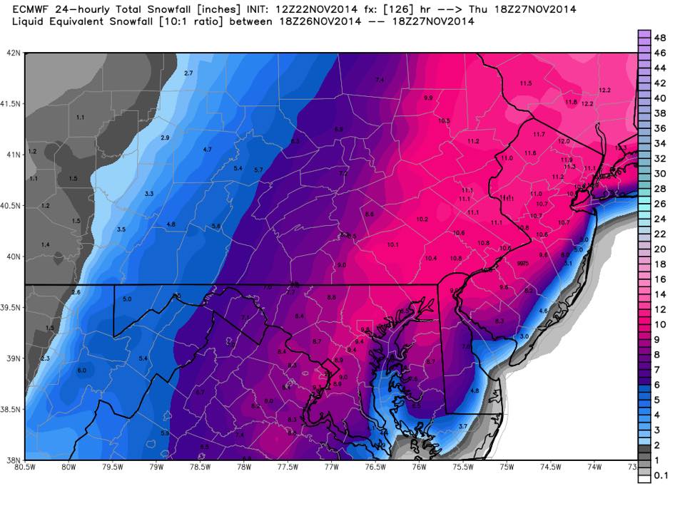
A 24-hour snowfall total map for the period from 6 p.m. Wednesday, Nov. 26 to 6 p.m. Thursday, Nov. 27.
“[The] new Euro [predicts] exactly 11.1 [inches of snow] in our area,” LVWA posted next to a photo of a 24-hour snowfall map for the period from 6 p.m. Wednesday to 6 p.m. Thursday.
The National Weather Service forecast for Hellertown for Wednesday as of late Saturday called for a 70 percent chance of rain and snow, with a 40 percent chance of snow Wednesday night.
A Hazardous Weather Outlook issued by the NWS at 7:53 p.m. Saturday stated that: “A coastal storm may produce snow or rain changing to snow which would impact holiday travel. If you have travel plans for Wednesday, please stay tuned to the latest forecast for more details as we draw closer to Wednesday.”


