
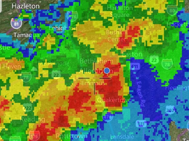
Weather radar shows a line of heavy thunderstorms moving across the Lehigh Valley area Sunday night. The storms are capable of producing very heavy rain, frequent lightning and damaging winds, which is why the National Weather Service issued both severe thunderstorm and flash flood warnings. Hellertown is located near the center of the above map.
Severe weather is affecting the Saucon Valley area Sunday evening, and now the National Weather Service has issued a flash flood warning for Hellertown, in addition to the severe thunderstorm warning that will remain in effect through 10 p.m.
The flash flood warning is in effect through 1:30 a.m. Monday.
According to a warning statement, “at 9:28 p.m. EDT, Doppler radar indicated thunderstorms producing heavy rain across the warned area. One to two inches of rain have already fallen in a short amount of time with additional rainfall moving into the area. Flash flooding is expected to begin shortly in the areas of heaviest rain.”
The National Weather Service said some locations that could experience flooding are Allentown, Bethlehem, Emmaus, Quakertown, Perkasie, Hellertown, Kutztown, East Greenville, Dublin, Topton, Bally, Bechtelsville, Pleasant Valley, Zionsville, Ancient Oaks, Geryville, Springtown, Gilbertsville and Fountain Hill.
Be especially cautious at night when it is harder to recognize the dangers of flooding,” the NWS warned. “Excessive runoff from heavy rainfall will cause flooding of small creeks and streams, urban areas, highways, streets and underpasses as well as other drainage areas and low lying spots. In hilly terrain there are hundreds of low water crossings which are potentially dangerous in heavy rain. Do not attempt to cross flooded roads. Find an alternate route.”
The storms that continue to pound the Saucon Valley area have also produced frequent lightning, along with strong wind gusts and hail in places.
“Minor damage to vehicles is possible,” the National Weather service said. “Wind damage to roofs, siding, trees, and power lines is possible.”
Continue to stay tuned to the latest forecasts for updates on the severe weather that is impacting our region.


