Fix Water Street Corridor to Improve Walkability in Hellertown, Report Recommends
Borough resident and geographer Michael Sutherland told Hellertown council one change that would immediately improve walkability in town would be the installation of ramps at the intersection of Harwi and W. Water streets, which is located in between the Main Street corridor and the Saucon Rail Trail/Water Street Park. The recommendation is included in his A Plan for People: Walking and Biking in Saucon Valley.
A Hellertown man and Saucon Source contributor who recently graduated from Penn State with a degree in geography presented borough council Monday with recommendations contained in his “A Plan for People: Walking and Biking in Saucon Valley;” recommendations he believes can help improve the borough’s walkability and bikeability–and ultimately liveability–if implemented.
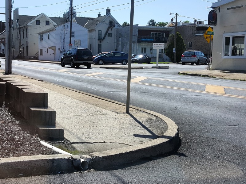
Michael Sutherland told council one change that would immediately improve walkability would be the installation of curb ramps at the intersection of Harwi and W. Water streets, which is located in between the Main Street corridor and the Saucon Rail Trail/Water Street Park.

The Water Street corridor is increasingly an important pedestrian route due to the park’s popularity. In addition to featuring amenities such as a new basketball court, a sand volleyball court and a playground, it is also the location of the weekly, seasonal Saucon Valley Farmers’ Market.
In spite of that, Sutherland pointed out, the non-ADA compliant Harwi street (alley) intersection is an obstacle to access, particularly for disabled people.
Just half a block away, however, new handicapped-accessible sidewalk ramps were installed at Front and W. Water streets last year.
Sutherland also recommended that the borough consider adding a traffic calming device such as a speed hump in Harwi Street, which is used by some of the traffic exiting the Main Street Dunkin’ Donuts.
“Drivers more often than not speed down Harwi Street after coming out the back end of Dunkin Donuts,” he noted.
The recommendations Sutherland made to council were formulated based on a detailed survey of local residents he conducted earlier this year.
The survey–which was shared by Saucon Source–sought to uncover obstacles to walking and biking in Hellertown, or the perceptions of obstacles as they exist in the minds of residents.
Sutherland said the primary obstacles to walking as defined by survey-takers are weather, motor vehicle traffic and distance.
Beyond weather, the obstacles to biking in the borough were identifed as “predominantly…the lack of bicycling infrastructure and motorist behavior,” Sutherland said.
Improving sidewalks and clustering businesses together will help make the community more walkable, he told council.
“I just want to applaud you for continuing to improve (sidewalks),” he said, adding that “predominantly it’s the eastern side of town which needs to be improved more.”
Another recommendation Sutherland made is the installation of a crosswalk in between Detwiller Plaza and the west side of Main Street, which he said is increasingly a popular crossover point because of the opening of Lehigh Valley Health Network’s new medical building at 708 Main Street.
“As we know, it’s almost impossible to cross Main Street,” he said. “You have to stick your neck out there and hope that somebody stops.”
The nearest crosswalk to Detwiller Plaza is across Easton Road at Main and Water streets.
Not far away, Sutherland said the overly wide intersection of New Jersey and Detweiler avenues in a residential neighborhood close to the center of town could be narrowed, and the excess space reclaimed for public use via conversion to green space–possibly even as a community garden.
Lastly, he said a longer-term project that could improve pedestrian accessibility at the south end of town would be the construction of a path connecting the Saucon Valley School District’s nature trail with Main Street and Tumminello Park, next to Neighbors Home & Garden Center.
The small park is next to Saucon Creek and opposite the Saucon Rail Trail, which it could connect with via a bridge.
The path between the SVSD nature trail and Tumminello Park could be along Polk Valley Road or cut through a corn field that’s located behind the Shoppes at Hellertown, Sutherland said.
“I’m very thankful for this opportunity to present on this topic which I’m very passionate about,” he told council. “I would love it if these ideas were implemented.”
Council president Tom Rieger complimented him on his work and said he hopes he will stay in the area, although Sutherland acknowledged that his current job search may require him to relocate to another part of the Northeast, such as Washington, D.C., or Philadelphia.
“I would love to stick around here,” he said. “It more or less depends on where I find work.”
Sutherland also thanked Renew LV for their assistance in helping him draft his report.
To read Sutherland’s complete 30-page “Plan for People,” click here.

Author