UPDATE: A flash flood watch is in effect for Lehigh, Northampton and Bucks counties, as well as other parts of eastern Pennsylvania, from 8 p.m. Monday through 6 a.m. Tuesday. In a statement, the National Weather Service said the potential exists for rain to fall at rates of 1 to 2 inches per hour, which could produce flash flooding along rivers, creeks, streams and in other flood-prone locations. “Urban areas will be of particular concern for flash flooding,” the watch statement said. Residents should monitor local weather forecasts and news outlets for updates on this developing weather event.
A potent weather system is expected to deliver heavy rains to eastern Pennsylvania Monday night, and depending on how it sets up, flash flooding could result.
Meteorologists from the National Weather Service office at Mount Holly, N.J., discussed the flooding threat in a forecast synopsis for the region Monday.
“At the moment, we are forecasting a widespread 1-2 inches of rainfall, but we will easily see locally heavier amounts where thunderstorms set up and train,” forecasters said.
The risk for severe weather is slight across southeastern Pennsylvania and southern New Jersey, with only a marginal risk across northern Pennsylvania, they added.
Parts of the Lehigh Valley including the Hellertown area are still recovering from a violent thunderstorm that produced straight line winds of up to 100 mph a week ago.
The destructive storm knocked out power to tens of thousands of PPL customers, some of whom did not have it restored for days, and produced a tornado in east Allentown near Bethlehem.
A section of Friedensville Road–which is a major east-west thoroughfare in Lower Saucon Township–was closed for nearly three days after trees and power lines fell on the road near Society Hill.
NWS forecasters said showers and thunderstorms will develop along a warm front across southeastern Pennsylvania this evening, becoming more numerous and heavier overnight.
“The storms should eventually move out overnight tonight as the warm front lifts north of the area as low pressure moves north and east towards Lake Erie,” the forecast discussion said.
Things will remain somewhat unsettled across the area Tuesday into Tuesday night, before sunny and dry weather returns on Wednesday, when a high of 81 degrees is forecast for Allentown.
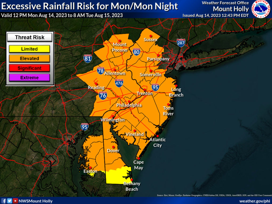
A National Weather Service forecast map highlights the elevated risk for excessive rainfall that will exist across eastern Pennsylvania, including the Lehigh Valley, overnight Monday. Forecasters say the heavy rain could lead to flash flooding. (Credit: National Weather Service, Mount Holly, N.J.)