
If the snow that fell Friday as the result of a clipper system and subsequent squalls wasn’t enough to convince you that Old Man Winter hasn’t given up his grip on the region just yet, a storm on Monday night and Tuesday just might.
According to the National Weather Service, a coastal storm is expected to bring snow to eastern Pennsylvania and much of the Northeast megalopolis during this period, although how much snow might fall remains a mystery.
“Accumulating snow is possible Monday night into Tuesday night,” the NWS at Mount Holly, N.J., said in a hazardous weather outlook Saturday. “There is still considerable uncertainty with details, including exact snow amounts, but there could be major impacts to travel especially during the day Tuesday.”
“At this point, the highest risk for accumulating snow amounts enough to cause major impacts is along and northwest of the Interstate 95 corridor,” the NWS said in a briefing that includes a snowfall forecast map which depicts the possibility of 4 to 6 inches of snow to accumulate in the Lehigh Valley area between 8 p.m. Monday and 8 a.m. Tuesday.
“The heaviest precipitation and strongest winds are expected to occur during the day Tuesday,” it said. “Precipitation is expected to taper off Tuesday night into Wednesday.”
A follow-up briefing that will address potential snowfall amounts for the 24-hour period ending at 8 p.m. Tuesday will be issued at 5 p.m. Saturday, the NWS said.
Residents should continue to monitor local and regional weather forecasts for updates on this storm, which could be the most significant of a winter in which relatively little snow has fallen and temperatures have been much above normal.
There have been two significant snow events to date. One on Feb. 9, when a little over seven inches of snow fell, and the storm Friday, which dropped 3-5 inches.
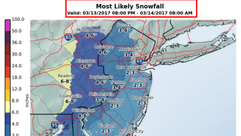
A National Weather Service map contained in a press briefing Saturday predicts that 4 to 6 inches of snow could fall in the Lehigh Valley area overnight Monday. Note: This map is not a snowfall potential map for the entire storm, which could last into Tuesday night, according to the NWS.


