Coastal Storm Could Drop Up to 18 Inches of Snow on Saucon Valley
The latest forecasts for a coastal storm predicted to affect the Saucon Valley area Monday and Tuesday include the potential for a ‘substantial’ amount of snow.
UPDATE: At 3 p.m. Sunday the National Weather Service upgraded the winter storm watch for the area to a winter storm warning for 8 to 18 inches of snow.
The latest forecasts for a coastal storm that’s predicted to affect the Saucon Valley area Monday night and Tuesday all include the potential for a “substantial” amount of snow to fall–possibly as much as 18 inches, depending on the track of the storm.
A winter storm watch for southeastern Pennsylvania and the Poconos has been issued by the National Weather Service for Monday evening through Tuesday evening, and blizzard watches have been issued for the New York City metro area.
According to the watch, heavy snow and strong winds are possible after the storm–the result of a Carolina coastal low pressure system–approaches the area from the southwest late in the day Monday.
“Snow will continue Tuesday into Tuesday evening…though some locations may see a brief break in the snow Tuesday afternoon,” the watch statement said. “The heavy snow will make many roads impassable and may produce widespread power outages due to the weight of the snow on tree limbs and power lines. Strong winds will lead to blowing snow, reduced visibility, and additional power outages.”
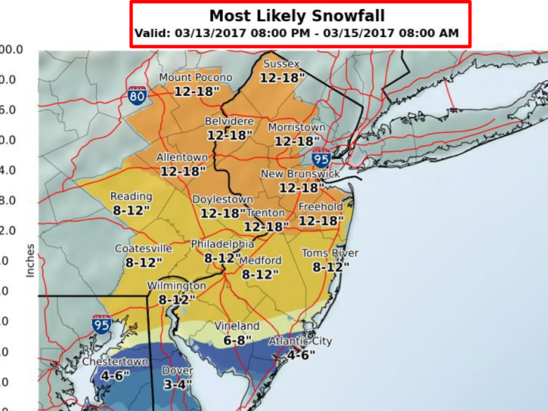
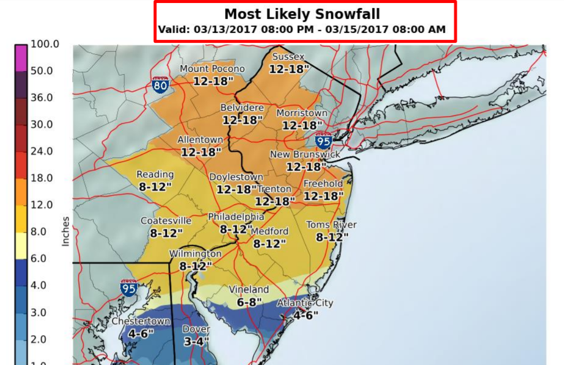
The “most likely” total snowfall amounts in the Lehigh Valley are in the 12-18 inch range, according to a map contained in a morning briefing issued by the NWS office in Mount Holly, N.J., Sunday at 5 a.m (below). The website PA Weather Action has also issued a first call map for the storm which puts most of eastern Pennyslvania in a zone where it says 12 to 18 inches of snow is likely.
Other maps in the briefing indicate that at least 4 inches or as much as 19 inches of snow should be expected, although the NWS lists its “confidence in snow amounts” as “low to medium.” Confidence in snow occurring is “high.”
“There remains uncertainty in exact totals, as a sharp gradient will exist between the heaviest snowfall and locations where very little snow may occur,” the NWS said Saturday. “Changes to the forecast track of the storm can result in substantial changes in the total accumulations.”
The next weather briefing about the storm will be issued at 5 p.m. Sunday.
Residents should continue to monitor their local weather forecasts for updates.
Author